Underground Utility Locating: New GPR Tech Makes It Easy
Modesto, CA-based ExceeD GPR & Locating focuses on safely locating underground utilities. The company has carved out a successful niche by using state-of-the-art equipment to help clients save time while reducing the risk of injury and costly damages. Exceed uses radio detection equipment and pairs it with the UtilityScan Pro ground penetrating radar (GPR) system to serve its client base which includes Pacific Gas & Electric (PG&E), real estate agents, major national & regional developers, and homeowners.
Company Focuses on Safely Locating Underground Utilities
Miquel Aguilar, CEO and senior radar technician of ExceeD GPR & Locating has worked on hundreds of underground utility locating and concrete scanning projects. The company focuses on locating underground mains, including telecommunication, electricity distribution, natural gas, cable television, fiber optics, traffic lights, streetlights, storm drains, water mains, and wastewater pipes.
ExceeD has developed a thriving business helping clients find underground assets on a property. “Calling 811 is just a part of the process,” says Aguilar.
“We find everything in the area, including on private property where an 811 call is limited, and the responsibility falls on a property owner.”
Aguilar acknowledges that he entered the utility locating industry by a somewhat circuitous route.
“I was in search of a truck to customize into a mobile clothing gallery for our clothing brand and I found the perfect one collecting dust in the yard of a concrete cutting company owned by a longtime friend. During the process of customizing the truck, I was asked if I could help the company with their GPR division.”
He adds, “I never really planned on it, but once I came into it, I found it very interesting. I enjoyed the training and was determined to master the GPR technology to become one of the best in the industry.”
After parting ways with his original company, Aguilar started to receive calls from prior clients about providing GPR services. This is when he decided to start his own service company.
“It was exciting to see something that we started from scratch grow and grow. My plan now is to build up the brand slowly, by bringing on others with the same kind of work ethic and who are truly dedicated to being masters of the trade.”
Aguilar prides himself on going the extra mile with customers and spends hours going over each site to learn as much as he can to ensure the job is executed as thoroughly and as accurately as possible.
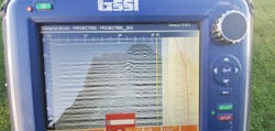
Aguilar uses radio detection equipment along with the GSSI UtilityScan Pro GPR system for quickly identifying and marking utility location and depth. The system features the GSSI SIR 4000 control unit and 350 MHz digital HyperStacking antennae.
The patented HyperStacking technology increases depth penetration of up to 40 feet in ideal soil conditions, while also providing high, near-surface data resolution. Typical depth penetration can range from 8 to 12 feet in California terrain, where Aguilar works.
GSSI offers a range of utility locating systems, including both two-dimensional and three-dimensional imaging systems. They are offered with a variety of accessories, including GPS and LineTrac, an optional add-on that helps locate AC power and induced RF energy present in conduits and utilities.
Aguilar specializes in doing two-dimensional real-time utility locations. He appreciates some of the features included in the advanced equipment, especially the data collection speed, real-time scanning and results, and the ability to quickly make adjustments and changes to accommodate different environmental conditions, like pavement, wet soil, average soil, or rocky conditions.
“With UtilityScan Pro, I can make decisions very quickly to improve the clarity and brightness of what I am seeing, especially for jobs I do at night.” He cites the example of a recent emergency survey required for a long-term client where he was operating in a rural area in the dark with limited lighting sources. He notes that this field of work doesn’t always fall between typical office hours and mentions a cell phone tower client where he has access to the area any time of the day, as compared to sites where he must meet up with a foreman or superintendent at a particular time.
“With the radio detection and GPR equipment, I am able to do quite a bit at most sites. It is extremely accurate. There have even been cases where clients are surprised and a bit concerned when I did not find an expected sewer line—then a week or so later they get back to me to let me know that even though the line was on the as-built plans, the utility never actually installed that line!”
On a humorous side note, Aguilar notes that a few clients continue to begin their locating projects by using dowsing rods or witching sticks to try to find utilities. “Waterlines emit some kind of energy or charge that is picked up by these historic tools and some clients continue to use them. I remind foremen for companies contracting with PG&E that they definitely cannot put that on their report—instead, we use equipment like the UtilityScan Pro to provide quantitative information!”
Proud To Be Part of California’s Future
ExceeD GPR & Locating has worked on projects all over California, from as far north as Eureka, down to Needles, in the Mohave desert near the Arizona border. With a client base that includes Mears, Snelson, Webcor, Devcon, Dellabarca, Gallo, Foster Farms, Overaa, Ford Construction, Nor-Cal Steel Structures, and PG&E, ExceeD has conducted utility locating in snow-capped mountains as high as 7,000 feet to deserts where temperatures topped 115°F.
Utility locating projects range from small, partial day surveys to ongoing, weeklong projects. One recent project was for the California Department of Forestry and Fire Protection (CAL FIRE), where Aguilar’s team was hired to locate underground utilities in a service hangar prior to retrofits.
Long-term client PG&E has hired ExceeD numerous times to locate underground utilities near and around natural gas line properties to ensure buried assets and utilities are clearly identified prior to the next phase of work being completed. The PG&E work is done under subcontract to the Mears Group, its sister company, Underground Construction Company.
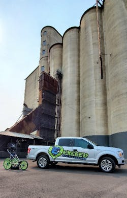
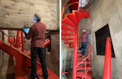
One interesting project was at the Modesto Silos, a redevelopment project by Modesto Silos and Royal Equity Investments, LLC, where ExceeD had to perform utility and concrete scanning services prior to renovations. He considers this place one of the most unique structures he has ever been in. “We are very grateful and feel honored to be a part of this amazing project in our very own hometown of Modesto, California.”
Keeping California Safe
The 2018 Common Ground Alliance Dirt Report indicated that there were close to 10,000 utility damages in the state of California. Aguilar is extremely proud of the work his company does for the private and public entities that have a focus on keeping the state safe.
“With all that we have gone through as a state, I think every project is very important. Everyone wants to be able to turn on their stove or take a warm shower. The services we provide make sure everyone can safely maintain access to all the essential utility services.”


